Continental Drift
We turn now to quite a different part of the world, a different time, and a very different topic. The topic is what is now called Continental Drift, the place is Paris, and the time is 1858. In that year Antonio Snider, an American working in Paris, published a book.This book [74] drew attention to the remarkably good match between the west coast of Africa and the east coast of South America. Snider suggested that this good match was because Africa and South America were once a single continent, which had been pulled apart in some way to form the present coasts (Fig.3.1). He gave a drawing of the combined continent, showing also Europe and North America joined, and even Australia joined to eastern Africa.
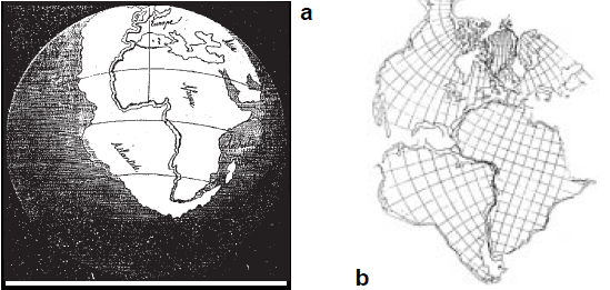 Fig. 3.1. Pre-Atlantic Ocean according to: a) Snider ; b) Bullard
This work was lost sight of in later years, but the topic was revived in 1915 when the German scientist Alfred Wegener published another book on the topic of how the continents were formed [82]. Wegener's work, unlike that of Snider, attracted considerable attention, and quite a lot of supporting comment. It really explained a lot, and if you could only accept the possibility that the continents could actually move relative to one another, the logic of the proposal seemed clear.
Nevertheless, over the years support again waned. It did not pick up again until 1964, when Sir Edward Bullard published a paper [13] which included a computer-based fit of the coasts of South and North America against Africa and Europe (Fig. 3.1). As this work was computer-based, of course it had to be right, and from that point on the concept of Continental Drift finally began to achieve general public acceptance; it only took a little more than 100 years!
This work considered only the lands on either side of the Atlantic. Some interesting observations had been made of the occurrence of fossils of a plant genus, Glossopteris, in rocks in Africa, Australia, India, South America, Antarctica, and New Zealand. Of course it is only a matter of logic that plants in the same genus must have had common ancestors, and these ancestors must have existed together within a single area -- otherwise they wouldn't have been able to breed.
Proposition 3A
Plants in the same genus must have had common ancestors,
and these ancestors must have existed within a single area
As the rocks containing the Glossopteris fossils are now widely separated, then using the principle of Continental Drift it was only natural to assume that these rocks were in continental masses which had drifted apart, and it was not hard to suggest how they had once fitted together (Fig. 3.2).
Further support for the idea came from a study of rocks which had been affected by an ancient glaciation, assumed to be an early south-polar icecap. Notice in Fig. 3.2 that India is part of this ancient super-continent, which has been called Gondwanaland. The drift of India northwards, and its collision with the rest of Asia, is usually assumed to be the cause of formation of the Himalaya Mountains.
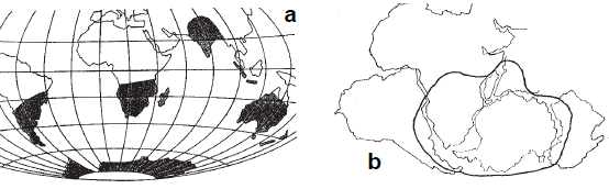 Fig. 3.2. a) Sites of Glossopteris fossils ; b) Suggested former
grouping of land around the South Pole
Fig. 3.2. a) Sites of Glossopteris fossils ; b) Suggested former
grouping of land around the South Pole
Additional confirmation for the occurrence of continental drift came from studies of magnetism in older rocks (paleomagnetism). Certain rocks are slightly magnetic, containing 'magnetic domains' which are areas of the rock magnetically aligned in a certain direction.
This magnetic direction is set by the Earth's magnetic field as the rock cools down from a hot state, and points towards the Earth's magnetic poles.
Our magnetic poles are in a different position to the geographic poles, and also vary slowly but continuously, both in position (currently the North Magnetic Pole is 11° away from the geographic pole, somewhere off northern Canada) and in strength. The polarity of the Earth's magnetism may also change, with the North and South magnetic poles interchanging in position.
By looking at the magnetic directions in old rocks of the same age, but in different continents, it becomes apparent that these continents must have shifted relative to one another -- the magnetic poles they point to are not in the same place. This technique has been used to trace the apparent movement of the magnetic poles over the Earth's surface in the past.
The parts of the surface which move as one have been called 'plates', and the study of their movement 'plate tectonics'. We will see later on that the term 'plate' is not an apt one.
The currently accepted position is that the northern continents of North America, Europe, and Asia without India were once a single super-continent (called Laurasia), which, together 24 with Gondwanaland, previously made up a single continent containing all the present land areas; this has been named Pangaea (Fig. 3.3). There is now convincing evidence that Pangaea really did exist as a single landmass about 200 my ago, and that it has since split apart, first to form Laurasia in the north and Gondwanaland in the south, after which each of these supercontinents again split further into parts, which drifted away to form the present disposition of the continents.
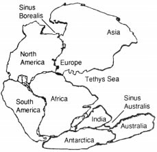 Fig. 3.3. A reconstruction of Pangaea
Continental drift has now "come of age"; the fact that it occurs is no longer seriously doubted, even by more conservative scientists. It is a good example of a scientific theory, one which explains many observable features of the real world in a simple, coherent, way, and for which no alternative and more simple theory has yet been put forward.
When it comes to the cause of continental drift, however, the position is very different indeed.
The Convection Current Theory
In searching for a mechanism for continental drift, geophysicists came up with the idea of convection currents. The interior of the Earth is commonly believed to be hot, molten in parts, and it was suggested that the molten rock moved in convection currents, like water boiling in a saucepan, and the movement of these currents forced the parts of the old supercontinents apart.The convection-current proposition for the mechanism of continental drift has achieved an amazing acceptance, and appears in all current standard geological textbooks. The acceptance is amazing because it is a proposition wholly without any supporting evidence or plausible basis. In my view it is completely wrong.
Of course the energy required to move whole continents around is extremely large. No plausible source for this energy has ever been suggested, as far as I know. No reason for the convection currents to break up into the assumed 'convection cells' has ever come forward.
Proposition 3B
The convection-current mechanism for continental drift lacks
any supporting evidence or plausible basis, and is completely
wrong
We will return to this point later on, and suggest an alternative mechanism for driving continental drift which does not suffer from these drawbacks.
Sea-Floor Spreading
During the 1960's, scientists came to learn a lot more about the structure of the sea bed, and some very interesting facts came to light. Of course, by this time, accurate methods of dating the ages of rocks were well known. A series of massive structures, called 'mid-ocean ridges' (Fig. 3.4), were discovered running down the middles of the major world oceans, and these were found to be the sites of volcanic activity, producing new rock (age zero years).As you move away from a mid-ocean ridge, you encounter progressively older rock, on either side. All the rock is of oceanic type, common to sea-beds all over the world, and quite different in nature to the rocks of the continents. The oldest oceanic rock, that most distant from a ridge, is only 200 my old.
Because much of the newly-formed rock had magnetic content, the paleomagnetic techniques described earlier in this chapter could be used to date the rocks in great detail. On either side of the ridge, 'stripes' of rock are being formed, with the edges of the stripes representing changes in polarity or strength of the magnetic fields. The ridgepoint itself looks like a mirror, with a pattern of stripes of given age and magnetic properties reflected on either side.
The picture given was quite clear and unambiguous. At the ridges, new rock was being formed along a roughly continuous line down the ridge, and spreading off to both sides to permit even newer rock to appear. It is perhaps understandable that these ridge-lines could be interpreted as the positions where convection currents were welling up from the Earth's mantle, bringing with them molten rock to solidify and spread apart.
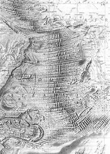 Fig. 3.4. Floor of the Atlantic Ocean
The phenomenon involved, called sea-floor spreading, appears to have created the whole of the present ocean floors during this period of 200 my. The rate of spread varies from one ridge to another, but is something like 2-4cm per year -- about as fast as your fingernails grow.
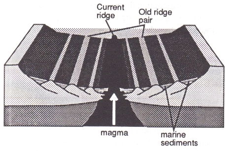
Fig. 3.5. Sea-floor spreading at a mid-ocean ridge
The fact that sea-floor spreading actually occurs is no longer in any real doubt. The driving mechanism behind it, however, is again quite a different story.
The 'Subduction Zones'
If the sea-floor was expanding at the mid-ocean ridges, where was the new surface material which was created ending up? The suggestion was made that it was disappearing down the deep ocean trenches, and either piling up under the continents, or being melted and recycled by the convection currents to appear eventually at another ocean ridge.Although this is the currently accepted dogma, it seems to me, and others (eg [20]), to be a concept which almost completely lacks any supporting evidence. It seems against logic, if one plastic plate is being pushed against and under another, for a deep trough to be formed between them. The deep ocean troughs are not continuous, and do not show any of the signs of rock in motion downward, deep into the Earth. And, in the case of the mid-Atlantic ridge, there are no deep ocean troughs along the Atlantic coasts for the re-cycled rock to disappear into.
Peter James, an engineering geologist, has looked at the position from the viewpoint of the physics of materials. He concluded that "serious difficulties exist in trying to reconcile the observed crustal features with a conventional model of mobile plate tectonics -- at least on our present knowledge of material behaviour" [45].
Another problem with the subduction theory is explaining away just where the huge volumes of rock involved are ending up. The whole of the present Pacific Ocean, an area representing around one-third of the entire current surface of the Earth (more than the total land area!), has opened up during the last 200 my. The bed of the Pacific varies in depth, but averages around 4 km below current sea-level.
Carey [17] has pointed out that the subduction theory just does not explain where these huge volumes of rock, more than a million cubic kilometres of material, ended up when the Pacific Ocean was created. If they were spread evenly under the present continents, these would be some 7 km higher than they are now, just with the material from the Pacific alone (current average height of the continents is no more than 1 km above sea-level). If the rock was really recycled in the mantle, to reappear at the mid-ocean ridges, then the Pacific would have always have had to have been its present size and depth, and not created from scratch in the last 200 my.
The subduction theory is thus a literal attempt to sweep a problem away under the carpet -- in this case, the carpet of the continents. Now is the time to drop this theory down one of the ocean trenches.
Proposition 3C
The subduction theory lacks supporting evidence and
plausibility, and is completely wrong
Expansion of the Earth
If we return now to Bullard's fit of Africa against South America (Fig. 3.1), you will notice that as you move away from the central point of contact, the match becomes less good. In 1955, Warren Carey, Professor of Geology at the University of Tasmania, pointed out [16] that the match would be much better if the two continents were curved around an Earth of smaller radius. This was the beginning of the current phase of the Expanding Earth theory.The basis of the Expanding Earth proposition is that the current continental masses were once all joined completely together, covering the whole surface of a much smaller Earth. This has since expanded internally, the current continents splitting apart and distributing themselves over the enlarged surface. In other words, the current deep-sea areas did not exist in their present conformation in earlier times, but have been formed by the expansion of the Earth's core under them.
At present, about 70% of the Earth's surface is covered by sea. If the present 30% surface which is land had to cover the whole of a smaller sphere, that sphere would be about 55% of the diameter of the present Earth. Instead of the current radius of about 6,400 km, the radius would have been around 3,500 km. The circumference of the present Earth is 40,000 km, but an 'unexpanded' Earth, in which Pangaea covered the whole surface, would have a circumference of about 22,000 km, that is, 18,000 km less than now.
It is interesting to calculate how long this expansion would have taken, at the present rate observed in sea-floor spreading. Since the rate at each ridge is around 2-4 cm/yr, and there are usually 3 ridges crossed in going right round the Earth, the total present expansion is very roughly 9 cm/yr. Dividing this into 18,000 km gives an expansion time of 200 my, which agrees quite well with the time from rock age-dating.
The Expanding Earth concept is not in conflict with Continental Drift, in fact we shall see that the two are closely linked. Under an expanding Earth, the single continent Pangaea which existed around 200 my ago would not have had the conformation shown in Fig. 3.3, instead the outer edges of Pangaea would have wrapped round a much smaller Earth and be in contact, thus enveloping the whole Earth.
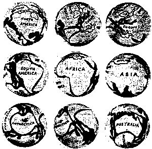
Fig. 3.6. Unexpanded Earth views according to Barnett
Further models of the pre-expanded Earth were constructed in the recent phase of interest, such as that made by Barnett [5]. Several views of this model are shown in Fig. 3.6. Notice that Barnett's model is fairly 'loose', with many large gaps not covered by land, and that some large movements and rotations of the land masses have been suggested, such as Australia moved against North America, Greenland moved a long way over the top of Canada, and so on.
Early Work on an Expanding Earth
As with the Continental Drift theory, there were earlier workers who had suggested the possibility that the Earth was expanding. One of these was Hilgenberg [42], who produced globes of the Earth at various stages of its expansion (Fig. 3.7). Fig. 3.7. Globes of Earth expansion according to Hilgenberg
A fascinating fact of history is that it was suggested as early as 1859 that the Earth was expanding; this was in a book by Alfred Drayson, entitled 'The Earth We Inhabit: its past, present, and probable future'. This book [28] came out only one year after Snider had published his early work on Continental Drift!
Drayson is described on the title page as 'Captain Alfred W Drayson, Royal Artillery, author of "Sporting Scenes in South Africa, &c" -- not the background one would expect for someone producing fundamental thoughts on the Earth's structure.
Much of Drayson's evidence for expansion does not stand up to examination in the light of modern knowledge, and he enormously overestimated the rate of expansion, at around 6000 cm/yr, as against the current estimate, one thousandth of the size. But it must be remembered that in Drayson's time, the great age of the Earth had not yet been established -- the accepted value then was perhaps 40,000 yr, so naturally the rates for associated phenomena would be well out.
Some of Drayson's observations are still valid. He noted unexplained fractures in deep undersea cables. In his day, these cables were clad in rigid iron. If the forces rupturing an undersea cable applied along its whole length, then expansion could have been at the rate estimated by Drayson. In fact they presumably only applied at mid-ocean ridges or 'plate boundaries', only at the places where the fractures actually occurred.
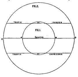 Fig. 3.8. Present and unexpanded Earth cross-sections, from Drayson [28]
Fig. 3.8 is a reproduction from Drayson's book. He says "perhaps it [the Earth] was once very small, perhaps as small as Fig.1., whilst the present earth is the size of the larger circle." It is interesting that the proportions shown in Drayson's diagram are very close to those currently assumed for an expanded and original Earth.
Copies of Drayson's book are quite rare, and its existence does not seem to have been picked up by anyone else interested in the expanding Earth idea. However, if you search long enough, you can almost always find a possible earlier reference -- the match across the Atlantic coasts was noted as early as 1620, by Francis Bacon! An even earlier reference to expansion of the Earth is that quoted at the head of this chapter. This is from the Zend-Avesta.
Thus Spake Zarathustra
The Zend-Avesta is the sacred book or bible of the Parsees, followers of Zoroaster. Zoroaster (another form is Zarathustra) was the founder of one of the most ancient religions still extant -- he was active in the area now known as Iran, at a date not known with certainty, but believed to be around 1000 BC.Of course the reference in the Zend-Avesta presumably has no scientific relevance, but it does justify the claim that expansion of the Earth has been a topic for some three thousand years!
ADDENDUM
Readers interested in the geological evidence for an expanding Earth should consult Warren Carey's new book "Theories of the Earth and Universe: a History of Dogma in the Earth Sciences" [18]. This gives a very thorough examination of the matter, and also brings out the knee-jerk tendency to react to revolutionary new ideas in science with ridicule, even when they are supported by the soundest evidence. If these ideas have the support of logic and evidence, then of course they do win out in the end, sometimes even bringing ridicule on those who rejected them out-of-hand when they first appeared!

(Full list of references at NURefs)
[5]. C H Barnett. A suggested reconstruction of the land masses of the Earth as a complete crust. Nature/ 4840 p447, 1962.
[13]. Edward Bullard. In: Symposium on Continental Drift. Royal Society of London, 1964.
[16]. S W Carey. Wegener's South America-Africa assembly, fit or misfit? Geol Mag/ 92(3) p196-200, 1955.
[17]. S W Carey. Lecture. Geology Department, University of Western Australia, 1987.
[18]. S Warren Carey. Theories of the Earth and Universe: a history of dogma in the Earth Sciences. Stanford University Press, 1988.
[20]. Bronislav Ciric. Is subduction a real phenomenon? In 'The Expanding Earth, a Symposium'. University of Tasmania, 1981.
[28]. Alfred Drayson. The Earth we inhabit, its past, present, and probable future. Bennett, London, 1859.
[42]. O C Hilgenberg. Vom wachsenden Erdball. Berlin, 1933.
[45]. Peter M James. Anomalous features of the Pacific: is sea floor spreading a real phenomenon? Pacific/ p205-209, 1987.
[74]. Antonio Snider Pellegrini. La Creation et ses mysteres devoile. Franck, Paris, 1858.
[82]. Alfred Wegener. Die Entstehung der Kontinente und Ozeane. Vieweg, Braunschweig, 1915.
NU004: The Distributions Of Nut Trees
NU002: How Plants Spread and Change
Version 1.0, printed edition ("Nuteeriat: Nut Trees, the Expanding Earth, Rottnest Island, and All That...", Planetary Development Group, Tree Crops Centre, 1989).
Version 2.0, 2004, PDFs etc on World Wide Web (http://www.aoi.com.au/matrix/Nuteeriat.htm)
Version 3.0, 2014 Sep 16, Reworked from Chapter 3 of "Nuteeriat" as one article in a suite on the World Wide Web.
Version 2.0, 2004, PDFs etc on World Wide Web (http://www.aoi.com.au/matrix/Nuteeriat.htm)
Version 3.0, 2014 Sep 16, Reworked from Chapter 3 of "Nuteeriat" as one article in a suite on the World Wide Web.