Geoprospecting
In NU013 we saw how deposits of 'fossil fuels' -- the high-carbon minerals derived from plants remains -- may have been associated with the seas and gulfs formed as the topmost domains of the Earth's crust split apart during Earth expansion.In this article we will look further at this, and also at how other mineral deposits were formed, the relationship of these processes to Earth expansion, and the practical application of this information to the discovery and exploitation of mineral riches.
Exploration geologists and prospectors have worked out many techniques for finding deposits of useful minerals. Most of these are based on knowledge of the rock types and formations with which particular minerals are associated -- say gold being often found in quartz veins, oil in folded layers of sedimentary sandstone, and so on.
It is then a matter of working out where in the world the favourable rock types are to be found -- and this has been surveyed in fair detail for most of the world's accessible land surface -- and applying more detailed tests to specific areas. Considerable help in recent years has been had from satellite observation data, but at some stage it is always necessary to start work on the actual ground. The ultimate test for occurrence of a mineral is that quoted at the head of this article.
We have seen that the analyses of plant distributions covered earlier in this book can be coupled with conventional geological approaches to enable reconstruction of the pre-expansion positions of different Earth domains.
For minerals formed early in the Earth's history, or derived from the ancient rocks formed then, we can use as a 'first-try' prospecting method a global approach which we can call 'Geoprospecting'.
As an example, if we know that the northwest part of Western Australia was once positioned against the eastern coast of Africa, we can look to see whether the minerals already known for that part of Africa are to be found also in Australia.
We already know this to be true for many minerals. Gold was an early example. The only major deposits of crocidolite, a blue asbestos mineral, are found in South Africa, principally in the Transvaal, and in Western Australia in the Hamersley Ranges. It seems likely that these two deposits were once physically linked as part of a huge basin of banded ironstone, laid down when the Earth still had a reducing atmosphere, well back before the 1000 my era.
In the last few years we have seen the discovery and development of large deposits of diamonds in the Kimberley region in the north of W.A. These parallel the deposits found in southern and eastern Africa. Perhaps the next major discovery in WA will be of platinum deposits, to parallel those already known from southern Africa (such a discovery was recently announced, in the West Australian newspaper of 1988 November 30).
Of course this 'Geoprospecting' technique can be applied to domains anywhere in the world, provided that the pre-expansion neighboring domains are accurately identified.
The Location of Coal Deposits
The techniques for locating fossil fuels are different to those for many other minerals, because the fossil fuels were formed in the later years of the Earth, when expansion had already begun to have major effects on the surface conformation. And, of course, since these minerals are derived from living organisms, they could not be produced until the relevant life forms had come into being, some 200-600 my ago.In NU013 the suggestion was put forward that many of our coal deposits have originated, not from land plants in the ordinary sense, but from floating forests on the surface of the sea (Proposition 13A). It was further suggested that these deposits were formed by the plant material sinking to the bottoms of the seas of those days, which were then much smaller and more shallow than now.
Most of our coal was laid down in the Paleozoic, and it appears from the patterns of change which have emerged from our study of Earth expansion that those former seabeds have now been superseded by new, deeper ones as the Earth opened up. These domain splittings, and the accompanying falls in sea-level, have left the majority of the Paleozoic seabeds up on dry land.
We might therefore expect to find coal in the interdomain gulfs created in the earlier days of the rupturing of the holodomain, the complete cap of continental rock which once covered the whole Earth. And the observed pattern fits in quite well with this. We have already noted how some particularly thick coal seams are to be found in the south of France and in northern India. Both these areas are ones which very probably lay on the Tethyan Girdle, the first major interdomain gulf which resulted from splitting the holodomain along the Equator into Gondwanaland and Laurasia.
Of course there are many major coal deposits, as in Australia and South Africa, which have nothing to do with the Tethyan Girdle. But they may well have been formed in other early domain splittings, and the whole thing can in fact be regarded as a two-way street. The observed presence of coal deposits implies the site of an early domain split, and conversely, prospecting for additional coal deposits should concentrate on areas where early domain splits may have taken place.
Proposition 14A
Paleozoic coal deposits identify the sites of Paleozoic interdomain gulfs, and unlocated coal deposits should be
looked for at such sites
Prospecting for Oil and Gas
We have seen that the conditions for deposition of oil and gas were probably similar to those for coal. However, the petroleum deposits were produced at a generally later date, with the majority in the Mesozoic. Therefore these deposits are most likely to be located in the vicinity of domain gulfs which formed as the Earth expanded during the Mesozoic and earlier.Again this scenario ties in quite well with the observed facts. Many of the major oil deposits are located on the Tethyan Girdle, including those of Texas, Venezuela, Mexico, North Africa, and the huge fields of the Middle East. The latter are illuminating in that they are now mostly quite distant from the major oceans, but represent a former major seafloor area which disappeared when Arabia, perhaps then still attached to other parts of Gondwanaland, was pushed up against Laurasia.
The fact that petroleum deposits have, as often as not, migrated from their strata of formation does not destroy this reasoning, it only implies that the possibility of migration must be kept in mind in evaluating any particular case. Of course even a fluid cannot migrate through an impermeable layer, and in the immense thicknesses found in the Mesozoic strata, measuring many thousands of metres, the probabilities are that the petroleum will encounter some form or other of trap before it has moved a very great distance.
We therefore end up with a similar proposition for petroleum as for coal, with a difference only in the age, and consequently location, of the seabeds involved.
Proposition 14B
Petroleum deposits identify the sites of Mesozoic or earlier
interdomain gulfs, and unlocated deposits should be looked for
at such sites
This Proposition is in accord with the fact that rich oil and gas deposits are often found on the continental shelves, at lower levels relative to coal, at the bottoms of presumed interdomain gulfs formed subsequent to those containing coal.
Field examination of this point may help sort out the question of where the Laurasia-Gondwanaland division should be drawn in the Southeast Asia-China area. The plant distribution evidence tends to suggest this should be roughly east-west along the mountains of south China, which would imply the possibility of significant fossil fuel deposits there.
But the evidence is not conclusive, the border could be much further south. Indonesia has significant reserves of both oil and coal in Borneo, Australia has much oil and gas in its Northwest Shelf and could have significant reserves beneath the Gulf of Carpentaria. And then again there may have been so much domain and microdomain mingling as to make any present-day line virtually meaningless.
Zone Melting and Ore Deposits
We have already seen (NU008) that considerable heat would have been generated through Domain Rubbing, as adjacent domains moved relative to one another. The nature of these movements, and consequently of the heat generated, leads to an interesting implication for the formation of mineral ore deposits.In recent years, a number of useful new techniques have been developed for the refining of mineral ores and other materials to produce products of great purity. In particular the zone refining technique (Fig. 14.1), one of the group of zone melting methods, has enabled the production of such things as the high-purity silicon wafers used in computers. The purity levels obtained are well beyond those available from any other method presently known.
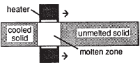 Fig. 14.1. The zone refining technique
In one zone refining method, a slab of the metal or compound to be refined is placed in a trough along which a heating ring can be passed in a slow and regular manner. The heating ring is activated at one end of the trough and enough heat applied to melt the disc of the material immediately within the ring. The ring is then moved slowly towards the other end of the trough.
As it moves, sufficient heat is applied in the ring to melt the new material moving under the ring, while the previously-molten material left behind cools and solidifies. The ring is gradually moved to the other end of the trough and the heat turned off, as one cycle of refining is finished.
What this process does is to dissolve minor impurities in the liquid zone as it reaches them, and continue to carry the impurities in the liquid zone as this moves to the other end of the trough. At the end of the cycle, the impurities have been partly removed from the main body of material and left in concentrated form at the far end of the trough.
It is normal to pass a material through a number of cycles, each of which improves the purity a little more. At the end of the process, the end of the bar of material containing the impurities is cut off, leaving a slab of material of very high purity.
There are many versions and modifications of this process. The slab can be replaced with a vertical cylinder of material, clamped at both ends, with the heating ring moving up or down, and with no trough or other support. In this case the thin ring of molten material is held in place between the solid portions purely by the surface tension of the liquid material. There may be a chain of heating rings, chasing each other along the trough, and far enough apart to permit solidification of the bar between one ring and the next.
The technique will also vary considerably according to the melting point of the material being used and the purpose of the work. In some cases, it is the 'impurity' which is wanted -- the rest of the bar is thrown away. In other cases, a material may be purposely 'doped' with an impurity which is spread through it evenly by introducing it at the beginning of the bar.
The method can be applied to a range of minerals, metals, gemstones, and even plastics. Whether it will work or not, in any particular case, depends on the physical and chemical relationships involved in the solution behaviour of the main material and the impurities.
The Formation of Precious Ore Deposits
The modes of formation of gold, silver, and other precious metals and gemstones have always been subject to uncertainty. Because the elements involved are, by their nature, rare, it is obvious that they have somehow become more concentrated from a medium in which they were originally much more diluted.There are satisfactory physical explanations for the formation of more common ores. The vast iron ore deposits of the Precambrian, for example, were almost certainly produced by simple precipitation of iron compounds washed into the sea. Salt beds were produced by evaporation of water from seas and lakes which had accumulated the salt dissolved by rain.
Some deposits originated through the action of life -- we have already seen this to be the case for the fossil fuels. Deposits of native sulphur may also have a biological origin.
However, virtually all primary deposits of precious metals, their ores, and gemstones are intimately associated with igneous rocks. Their mode of occurrence is consistent with the views that great temperatures and pressures have been involved. Where did these temperatures and pressures come from?
The conventional view is that the heat came from inside the Earth, and the pressure from the weight of overlying rocks. I have suggested in this book that the Earth is not especially hot inside, and perhaps never was, but instead that the heat involved in volcanos and geothermal processes of every kind comes from the friction of domain rubbing.
It seems only reasonable that this frictional process is the source of the heat needed to make these precious metal and gem deposits. It also seems very reasonable that the interaction of the domains is at least one source, and possibly the major source, of the high pressures involved.
Proposition 14C
Precious metal and gemstone occurrences were produced
through processes involving the frictional heat and high pressures
generated by domain rubbing
This Proposition is supported by the observation that gold and gemstone deposits are much more commonly associated with 'long' mountains such as the Andes, themselves generated by domain rubbing (Proposition 8C), than with the 'fat' mountains such as the Himalayas which are presumed to result from domain impact.
Moreover, the essentially localized nature of the heat produced by domain rubbing gives a much more satisfactory explanation for the localized nature of precious ore deposits. These are hard to explain on the basis of heat diffusing or being carried up from some vast internal reservoir beneath the Earth.
There is another interesting feature of domain movements, which leads to quite a different aspect when you look at the heat of ore formation. These movements are not continuous, they go in discrete steps. We call these domain movements earthquakes.
Earthquakes as a class are not rare, there may be over a million of them occurring somewhere on Earth each year. The vast majority are very faint and only detectable by instruments, only one or two out of the million may cause public concern. But on and on they go, these Earth-twitches, all in all representing a gigantic amount of energy release.
And there is the likely cause of precious ore genesis. Active domain rubbing sites can be viewed as gigantic zone-refining factories, concentrating the precious ores as wave after wave of heat comes through from twitch after twitch.
Proposition 14D
Precious metal and gemstone ore deposits are formed by a
natural zone-refining process, with the heat needed stemming
from the friction of earth-twitches as domain edges rub
The Uses of Domainography
All the areas of mineral exploitation that we have looked at in this article -- geoprospecting, the location of coal, oil, and other fossil fuels, and the formation of precious ores -- are all facets of the field of domainography. This field of study, which started from observations of where different nut trees were to be found in different parts of the world, clearly has an immense but still uncharted usefulness for the world's industry and commerce.Later we shall look more closely at implications for other aspects of the interaction of mankind, and of life in general, with these ponderous processes going on in the Earth. But first we will move off the Earth itself, and have a brief look at the rest of the Universe

NU015: The Moon and the Planets
NU013: The Origins Of Fossil Fuels
Go to the NUSite Home Page

Version 1.0, in printed edition of "Nuteeriat: Nut Trees, the Expanding Earth, Rottnest Island, and All That...", 1989.
Version 2.0, 2004, PDFs etc on World Wide Web.
Version 3.0, 2014 Sep 10, Reworked from "Nuteeriat" as one article in a suite on the World Wide Web. V. 3.1, Adjusted, 2025 May 31.
V. 4.0, Adjusted for *, 2025 Oct 1.