


Fixed-Earth and Expanding-Earth Theories -- Time for a Paradigm Shift? -- Version 2
David Noel
<davidn@aoi.com.au>
Ben Franklin Centre for Theoretical Research
PO Box 27, Subiaco, WA 6008, Australia.
Prologue
But Scientists, who ought to know,
Assure us that they must be so....
Oh! let us never, never doubt
What nobody is sure about!
From The Microbe, by Hillaire Belloc
Introduction
We can characterize those theories which assume the Earth has maintained an essentially fixed radius over geological ages as Fixed-Earth theories, and those which assume that the Earth’s radius has increased markedly over such ages as Expanding-Earth theories.
Fixed-Earth theories assume that the Earth has always been as it overtly appears today, and, due to lack of considering contrary evidence, is the currently-accepted paradigm among most scientists and the general public.
But examining the accumulated evidence supporting Expanding-Earth theories now makes Fixed-Earth totally untenable, and it is time for a paradigm shift to recognize Expanding-Earth as the accepted norm.
This article reviews the accumulation of evidence and deduction over the past several centuries, with indications of how this evidence best fits one or another of these theories.
Brief history
The scientific bases for both Fixed-Earth (FE) and Expanding-Earth (EE) theories had their origins back in the 1850s, though earlier thoughts on movement of continents had been expressed as soon as the coastline of eastern South America had been mapped and its similarity in shape to the west coast of Africa noticed. Interestingly, ancient Parsee texts dating back 3000 years refer to the Earth expanding.
More detail on the history and development of these theories appears in my book "Nuteeriat" [1], now available online. Here I examine some of these matters with respect to how they they accord with conventional FE theory, and EE theory as advanced here.
The concept that parts of the Earth's land surfaces have moved relative to one another forms part of both FE and EE theories, and these days is hardly subject to doubt. In Fixed-Earth terms, the continents have "drifted" apart, moving as 'tectonic plates', while in Expanding-Earth terms, the planet has expanded under the present continental surfaces, leaving them separated in a similar way that small pieces of paper stuck on the surface of a partly-inflated balloon would appear to move apart as inflation continued.
A vital difference between FE and EE here, is that EE asserts that the current land masses once covered the whole surface of a smaller-radius planet.
EE theory embraces a natural explanation for how and why movement occurred. On the other hand, FE theory requires an as yet unverified mechanism to accomplish movement of land areas about the surface of a fixed-area Earth.
Inside the Earth
We have direct knowledge of the material within the Earth only from mines and boreholes. The deepest drilled to date, in the Kola Peninsula in Russia, was begun in 1970 and reached 12,262 metres 19 years later.
Virtually everything else we think we know about the Earth’s inner structure has been worked out from seismological studies -- earthquake waves. These suggest that the Earth can be divided up into five layers from surface to centre, with ‘discontinuities’-- places where physical properties such as density change abruptly -- between each layer [for more detail, see "Nuteeriat" [1]].
The top layer, called the Crust, extends from the surface down to the Mohorovicic Discontinuity or ‘Moho’, some 30-40 km deep. Below this is the solid Upper Mantle, down to about 700 km, and the solid Lower Mantle, to a depth of about 2900 km.
Below this is the Outer Core, interpreted as a liquid zone, down to about 5150 km, then the solid Inner Core, down to the Earth’s centre at 6370 km (different behaviour of earthquake waves in liquids and solids leads to this interpretation).
Everything else, including things such as the Earth having an iron core, is really only speculation. Even the seismology-derived data may not be especially accurate -- seismology predicted that the Kola drillhole would yield sedimentary rock to 4.7 km, then 2.3 km of granite, and basalt below 7.0 km. In actual fact the bore yielded sedimentary rocks to more than 7.0 km, and granite after that to the 12.3 km maximum reached, with no basalt found.
Sea-floor spreading
Over the last 200 or so years, our knowledge of the Earth’s crust has been continuously improved as more areas were geologically explored and mines and boreholes dug. But the most dramatic and unexpected discovery during this period has been the phenomenon of sea-floor spreading.
Beginning in the 1960s, all the world’s ocean beds were surveyed and sea-floor rock samples taken. It was found that along ‘mid-ocean ridges’ in the major oceans, new molten rock was being created and pushed aside by later activity. From dating of these rocks, it was established that they were being laid down in parallel stripes on either side of the ridges.
At the ridges themselves, the new rock was of age zero years. The stripes on either side were made up of rock which got older, the further from the ridge, and so appeared as if reflected in the ridge. The oldest sea-bed rocks found were only 180 million years old, young in geological terms, so none of today’s deep oceans existed on the Earth 200 million years ago (the Earth itself is about 4600 million years old).
In many locations, this mid-ocean ridge was found to contain a gigantic cleft, or rift, 32-48 km wide and about 1.6 km deep, extending along the crest of the ridge. The ridge itself does not form a smooth path, but is instead offset in many places. The offsets are called fracture zones, or transform faults (Fig. 1a).
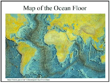
Fig. 1a. Mid-ocean ridges, sites of seafloor spreading. From Elizabeth Ruth Goeke's website at MIT [2]
Additional information came from sea-bed rocks which contained magnetic minerals. When these cooled from the molten state, the magnetic minerals took on orientations according to the Earth’s magnetic field of the time (this varies in strength, direction, and polarity). So these minerals give an indication (paleogeomagnetism) of the positions of the magnetic poles at the time of formation.
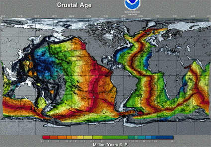
Fig. 1b. Ages of rock bands on the ocean floors, figure somewhat reduced from [3].
Figure 1b shows the disposition of rocks of various ages on the beds of Earth’s oceans. No theory of the Earth can be acceptable which does not give a satisfactory explanation of this data.
Pangaea and Panthalassa
Both FE and EE theories include the assumption that around 200 million years ago, before the current deep oceans were formed, all the present land masses were aggregated into a single large land mass, ‘Pangaea’ (Figure 2).
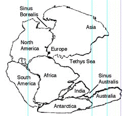
Figure 2. Conventional (FE) representation of Pangaea.
Figure 2 shows one of the older FE reassemblies of the continents. It is based on the long-held former connection of South America with Africa, and the parallel North America/Europe connection. India, Antarctica and Australia are linked in with Africa because of links indicated by ancient Glossopteris plant fossils.
More recent FE studies have made scarcely any advances in the Pangaea reassembly model. What changes have been put forward usually use paleogeomagnetic data to suggest some quite extraordinary rotations and juxtapositions of present-day land areas.
The FE model contains truly major deficiencies in explaining seafloor-spreading data. Because it assumes Pangaea (a combination of current land areas, amounting to some 30% of the current Earth surface) existed on a globe of the present size, it necessarily assumes that the remaining 70% of the Pangaean Earth’s surface was a huge sea, Panthalassa, enclosing the single continent.
We have already seen that all the present deep oceans are less than 200 million years old. Therefore, if the FE theory was correct, more than 70% of the current Earth's surface must have disappeared without leaving any trace during the last 200 million years.
With new rock surface being created at mid-ocean ridges, FE theory has struggled to explain where old rock has been removed to keep the surface the same total size. The suggestion was made early in the piece that surface was being consumed by 'subduction', with sea-bed rock pushing down ocean trenches and under the present continents.
In spite of the fact that the 'subduction' concept lacks any direct supporting data, it has achieved an amazing acceptance as part of the current FE paradigm, even appearing in books issued to primary-school students and the like.
A simple illustration of its falsity is as follows. The Pacific Ocean today occupies about 33 % of the Earth's surface, and has an average depth of about 4 km. The current land areas amount to about 30 % of the surface, and have an average elevation of about 700 metres.
So if just the material from formation of the Pacific was pushed under and evenly distributed under all the current land areas, these would have an average elevation of at least 4000 metres. If the material from the other deep oceans was added, it would bring the average elevation up to about 9000 metres. This is clearly not the case.
When 'spreading' site lengths are totalled up, this value is some three times greater than the length of assumed compensating 'subduction' sites which are supposed to receive the new material from spreading[17].
In EE theory, on the other hand, while Pangaea existed, it was wrapped around the whole surface of a much smaller globe, with around half the present radius. Seafloor spreading then appears as a natural expression of Earth expansion, with no need to call on dubious ideas such as subduction to explain observed data.
Re-assembling Pangaea
Obviously if Pangaea occupied the whole surface of a smaller-radius Earth, it would be of interest to know exactly how the current continents and land areas were once in contact. Several successful methods have now accomplished this, working in different ways.
In his masters thesis, James Maxlow [4] used a simple large-scale method, working from oceanic seabed rock ages like those in Figure 1b. Examining the younger stripes alongside sea-floor spreading ridges, he calculated the reduction in surface area after subtracting these stripes, and fitted the remaining older surface together on a globe of appropriately smaller size.
Then by subtracting successively older stripes and fitting the remaining surface onto smaller globes, Maxlow gradually drew together the land pieces until they were in contact. Maxlow's work [4] has animated graphics showing the Earth at different expansion stages.
Maxlow has since completed a doctoral thesis which is available on the Web [5]. This work contains all the hard data needed to convince the most sceptical reader of the accuracy of Maxlow's views on Earth Expansion.
My own method of demonstrating the occurrence of expansion, described in "Nuteeriat" [1], worked from a completely different direction, based on plant distributions. A group of plant species which are related must have had common ancestors from which they are descended, and these ancestors must have been together in the same area in order for them to breed and produce offspring.
Their modern descendants which are now in widely-separated parts of the World must have ended up there by normal plant-dispersion mechanisms, or by movement apart of sections of surface which contained the original ancestors.
Surprisingly, the second mechanism is overwhelmingly predominant. This is shown by the fact that complete ecologies of unrelated plant species, with very differing dispersion mechanisms, have suffered the same shifts, and also by the patterns of distribution, with modern relatives ending up many thousands of kilometres apart, far beyond the reach of accepted seed dispersion mechanisms.
As examples, plant species in northeast Australia are closely related to those in northwest South America, those in Tasmania and New Zealand are close relatives of Chilean species. In some instances, the same species is regarded as native to two areas, currently separated by over 10,000 km of Pacific Ocean.
Maxlow's method of reassembling Pangaea is essentially mechanical, and the plant distribution approach also has a mechanical approach, but with more power and ability to handle detail. This technique has been called 'rubber-banding'.
The Earth's surface is first divided up into numerous 'domains', bounded by natural physical features such as mountain ranges, substantial bodies of water, rift valleys, and the like -- essentially areas which are likely to have undergone some degree of relative movement against their neighbours.
Then for a particular spot -- isolated oceanic islands work very well -- the modern distributions of all plant species are linked together within 'rubber bands', one for each species or family group. The rubber band for a single species will be a strong one, that for all species within a subgenus slightly weaker, and so on with progressively weaker bands for a genus, a subfamily, a family, and so on.
All the rubber bands are then contracted down, drawing together expansion-related land areas into a single whole. This process could be computerised, but simple graphic methods have shown the results are the same for any chosen area, anywhere in the world, and have an accuracy approaching 100 km in re-assembling areas separated by Earth expansion.
I have applied the technique to over 100,000 plant species -- a good proportion of all existing -- with completely consistent results and no exceptions. For the Earth's land surfaces, simple topology means that all these land surfaces must have been in contact with other land surfaces in the past, along all boundaries, and so Pangaea must have covered the whole of a smaller Earth.
Paleogeomagnetic data, from observation of magnetic directions in seafloor-spread rocks, can also be used to support the same conclusion, Unfortunately, workers in this field have tended to assume a fixed Earth as a base-point for their calculations, and ended up with some extraordinary suggestions of past land layouts. Paleogeomagnetic data is intrinsically weaker evidence, consisting of time-dependent vector data only. This data can easily match by chance or by time error, while plant-distribution data works at DNA-structure levels, and cannot match by chance.
More recently, Dennis McCarthy [6] has independently arrived at the same conclusion with regard to the matching of related plant groups on either side of the Pacific Ocean.
Parasolids
Careful measurements on very old panes of window glass have shown that these panes are thicker at the bottom than at the top.
This has occurred because glass can actually flow under gravity, though at a very slow rate. Glass is an example of a parasolid, a material which for smaller time duration and lesser bulk behaves as a typical solid, but for longer times and larger masses can be treated as a highly viscous (and often granular and anisotropic) material which can flow.
Rocks are also parasolids and subject to parasolid deformation. The material for which we have perhaps the best parasolid-deformation data is water rock -- ice as found in glaciers, studied over many years.
The flow of crustal rocks is described by Cliff Ollier in a book chapter "The Flow of Ice and Rock" [7], describing the phenomenon as 'plastic flow'. Ollier also describes flow in old marble mantelpieces and tombstones.
I prefer to use the term 'parasolid deformation', especially for movement of matter below about 30 km in the Earth (the Mohohovicic discontinuity?), as I suspect that mechanisms operating at depth may differ from any applying closer to the surface. Tassos [18] has developed an approach called Excess Mass Stress Tectonics (EMST) which concludes that faults in rocks can only exist, other than momentarily, above the same 30 km depth limit. EMST also has a differing view on how energy is contained in deep rocks.
The flow of ice in glaciers has yielded some interesting evidence. One point is that the size of ice crystals in a glacier increases with distance travelled. In a long glacier, such as some of those in Antarctica, ice crystals at the calving point where the glacier enters the sea may be hundreds of times larger than those at its origin.
Another point about glaciers is that their movement at the bottom is faster than that at the top. This is a main reason for the formation of crevasses, huge splits in the glacier surface which taper down to sometimes considerable depths.
In 2003 I had the opportunity to fly above some calving Antarctic glaciers, and was struck by the crevasse patterns produced in the resulting icebergs. These patterns were not random, but were oriented across the glacier flow direction, or sometimes perpendicular to this, giving a crisscross pattern.
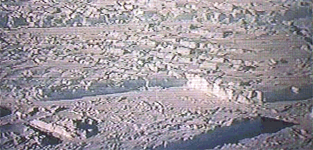
Fig. 3. Rectangular patterns in calving Antarctic glacier.
In 2004 I visited Canada's Pacific Geoscience Centre on Vancouver Island, British Columbia. One of the exhibits on display was a huge relief model of part of the British Columbia coast, which has many strong relief patterns such as mountain ranges and fjords. The pattern was somehow familiar, and later I realized that this area mimicked the crevassed Antarctic icebergs, with clear separation into rectangular blocks, but on a much larger scale (Fig. 4a.).
The sea-level fjords occupying some of the BC block boundaries were heavily glaciated in the past, however glaciers only follow existing valleys, rather than creating them. No mechanism is known whereby glaciers could cut zig-zag patterns in an elevated massif.
Similar zigzag/ rectangular patterns can be picked out easily in other elevated massifs, such as the Katherine Gorges area of Australia's Northern Territory, or the Grand Canyon area of the US Rockies. Comparison of strata levels on opposite sites of the Grand Canyon suggest that the Colorado River merely follows parts of a rectangular crack system created in the Rockies, rather than having cut its own bed, as is often stated.
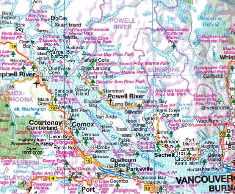
Fig. 4a. Southern British Columbia coast. Note the rectangular zig-zag pattern of Jervis Inlet and other features. From [8].
Examination of the detail around mid-ocean ridges (Fig. 4b) shows that these areas, too, are very clearly delineated into rectangular-block patterns. These large-scale block patterns seem to be an expression of Earth expansion. Conventional Fixed-Earth theory has no explanation for them.
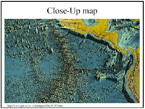
Fig. 4b. Mid-ocean ridge detail off Central America. From [2].
In fact, the whole physical relief of British Columbia, from the Canadian Rockies westward to and into the sea, appears very much as if the province has slumped down westward over geological time. The long lakes or rivers running parallel to the coast are very prominent (Fig. 5).
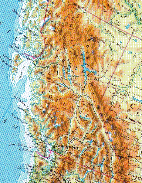
Fig. 5. Relief patterns in British Columbia. From [9].
Tectonic plates or Domains?
A major difference between FE and EE theories is the way they treat parts of the Earth's surface which have been subject to relative movement in the past.
In FE theory, the whole of the Earth's surface, including all the seabed, is treated as divided up into so-called Tectonic Plates, numbering perhaps 10-40, according to the criteria used. Each of these rigid plates is supposed to move as a whole, as if floating, on the subcrustal regions.
The depth of these 'plates' is never explicitly stated, but a common assumption is 30-80 km. The whole idea of such 'plates' existing is completely fallacious, unsupported by any evidence and in stark contradiction to known laws of physics. How could such entities be floating, when the closest liquid layer is some 2900 km down?
Of course gross movements of parts of the Earth's surface do occur, that is fundamental to both FE and EE theories. One well-documented movement is along the west coast of North America, where the 'Pacific Plate' is moving northward relative to the 'North American Plate', and allegedly disappearing down the Alaska Trench.
There is no doubt that such a relative movement is occurring and is quite substantial, amounting to many kilometres over geological time. One of the modern manifestations is the well-known San Andreas Fault in California.
One question which might be asked of FE adherents is, if the 'Pacific Plate' has moved many kilometres northward, what happened at the southern end of the plate? Is there a big gap in the seabed, maybe 30-80 km deep, which we haven't yet discovered?
A feature of the FE 'Tectonic Plates' which should be noted is that they are treated as rigid, and capable of rotation as a unit. Some amazing rotations of these plates have been postulated by Tectonic Plate adherents, without any explanation of the effects of such rotations on surrounding 'plates'.
'Convection Cells' and 'Subduction'
Failure of a suggested underlying mechanism for a theory explaining observed data does not invalidate the theory itself, nor does the absence of such a mechanism. For example, no underlying mechanism is put forward here to explain why the Earth is expanding. But the conventional FE mechanism underlying 'tectonic plate movement' is so ludicrous as to cause wonder as to the extent to which 'scientists' can ignore well-known laws of science in seeking an explanation of observed data.
FE theory explains plate movements as caused by 'convection cells', circulating cells of matter rising, moving horizontally, and descending, like the movement of water in a boiling saucepan (Fig. 6). Although this mechanism appears widely, as in school textbooks, on close examination it scores very low down on the credibility scale. Convection cells can only form in fluids, and the nearest planet-scale fluid rock to the 'tectonic plates' is in the outer core, some 2900 km down.

Fig. 6. "Sketch showing convection cells commonly seen in boiling water or soup. This analogy, however, does not take into account the huge differences in the size and the flow rates of these cells". The illustration and the caption are from [10].

Fig. 7. "Conceptual drawing of assumed convection cells in the mantle. Below a depth of about 700 km, the descending slab begins to soften and flow, losing its form". The illustration and the caption are from [10].
Another point which becomes trivial in the light of the fact that the Mantle is not fluid, is that the rise of fluid in convection cells is ultimately because less-dense fluid moves upwards towards regions of lesser gravity. The force of gravity actually decreases with descent into the Earth's interior, so everyday convection-cell mechanisms should not apply anyway.
Giancarlo Scalera [14] has carried out a detailed analysis of the past history of the Mediterranean, using a great deal of seismic data to interpret past events in deep formations. Past interpretations have suggested that subduction was occurring in various places, including subduction in opposite directions from two parallel bands only around 100 km apart -- an obvious impossibility. Scalera concludes that the Mediterranean lands are moving apart under expansion, with the Mediterranean on the way to becoming an ocean.
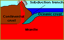
Fig. 8. The FE concept of 'subduction'. From [11].
In my view, it would not be unfair to characterise the Subduction and Convection-Cell hypothesis as the 'Phlogiston Theory of the Twentieth Century'. Maybe OK as a first try, but stack it up against actual evidence, and the concept is immediately invalidated.
According to the hypothesis, material 'subducted' into the convection cells is later recycled to rise up as new ocean floor at the mid-ocean ridges. If this were really the case, then the composition of the new rocks might be expected to vary, according to the nature of the crustal material recycled. In reality, as Ollier points out [19], all new mid-ocean ridge material is basalt of uniform composition (mid-ocean ridge basalt, commonly known as MORB).
Domains in EE theory
EE theory represents crustal parts in a different and far more general way. Any part undergoing relative movement is called a 'domain', and an individual domain can be any size from a few kilometres across right up to continental dimensions. Conventional continents can be treated as made up of aggregations of domains of various sizes, with domain edges defined by any marked physical feature, such as the centreline of a mountain range, seashores, edges of deep lakes or islands, ocean trenches, and rift valleys.
Moreover a domain can be any thickness, from perhaps 1000 metres up to full crustal thickness, and small domains can move on top of larger domains, giving a 3-dimensional interpretation of crustal movements (FE theory is essentially 2-dimensional). What FE would call 'tectonic plate boundaries' are, in the EE approach, merely linear features where relative horizontal movement is occurring, and the ad hoc connection of these up into specific 'plate boundaries' is irrelevant.
Thus EE theory has no 'tectonic plates', and so avoids difficulties associated with explaining what happened at the 'opposite' end of a 'plate'. Of course 'domain edges' are not regarded as fixed over time.
In addition, EE domains are treated as made up of deformable, rather than rigid, material. This material can be thought of as similar to the sorts of lumps which form in brown sugar. These lumps have some self-cohesion, and can be gently moved without losing shape. With more pressure, however, these lumps break up or deform, and strong twisting or impact forces lead to crumpling rather than rotation.
The implication of this brown-sugar model is that large portions of the Earth's crust obey mechanical deformation laws closer to those applying to scaled-up brown-sugar aggregates than those applying to scaled-up pebbles or rock pieces.
Movement of domains
FE theory essentially provides only the convection-cell model, operating on continent-scale principles, to explain crustal-part movements. With EE theory, most larger-scale movements will be as a result of expansion -- essentially, the parasolid underlay is pulling out from under the crustal parts, like carpet being pulled out under a beanbag.
In addition, analysis of movement of small domains (working from biometric data) shows a clear expression of domain movement away from the equator, with greater distances being moved by smaller domains. There is more detail on this in "Nuteeriat"[1], but as one example, the New Zealand flora has almost a tropical appearance, with very few deciduous trees, and its plant links are with areas often much closer to the equator. In contrast, the larger Australian landmass shows much fewer such links in its southern latitudes.
No definite mechanism has been established as to why smaller domains have retreated faster from the equator, but the notion that they have is, in my opinion, well established.
FE theory has no explanation or mechanism for such movements.
Terranes
One of the intriguing discoveries of recent years has been that of terranes. Near-coastal areas of the larger continents, such as western North America or eastern Asia, have been found to be made up of a collage or patchwork of small areas ( a few kilometres on a side) drawn from vastly different geological types and ages. As an example, one such terrane is said to have originated close to the equator, moving north and splitting in half, with one half found in Idaho and its identical twin ending up in Alaska [12].
FE theory has no explanation for such occurrences. In EE theory, these terranes are merely micro-domains and their rapid and chaotic movement is only to be expected.
Ocean trenches
In FE theory, the deep ocean trenches are regarded as sites where excess surface created by seafloor spreading is disposed of, 'subducting' under the adjacent continents (Figs. 7, 8). We have already seen that when considering the masses of material involved, this explanation is logically unsound.
Further discrediting of the idea comes from consideration of assumed 'subducting' ocean trench lengths and their positions on the Earth. The total length of all 'subduction' zones is only one-third the total length of spreading zones [19]. The South Atlantic Ocean has an active spreading zone, but no ocean trenches or other identified 'subduction' zones running along the coasts of Africa or South America to receive excess material.
Moreover, the actual conformations of deep ocean trenches are not in accord with what might be expected from the FE assumptions. They are up to 11 km deep (in the Marianas Trench, in the western Pacific) and according to Hayford [13] the slope of their sides are mostly at 5 degrees from vertical, both on the landward and seaward sides, and any sediment beds they contain are horizontal.
From the rock mechanics viewpoint, it doesn't really make sense if you are pushing one mass of rock against another for a gap or trench to form between them. Actual ocean trenches show no evidence at all of massive amounts of material being tipped down them from one side, and if such was occurring, one might assume that they would all have been filled up during past geological ages.
In considering how ocean trenches might have originated, FE theory has no explanation. In EE theory, ocean trenches are a natural consequence of expansion of the parasolid interior under the crust, as also are rift valleys and mid-ocean ridges.
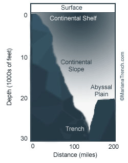
Fig. 8b. Mariana Trench profile diagram. From [16]
Benioff zones
Most earthquakes have their centres at varying depths down to about 80 km, but occasional 'deep earthquakes' are noted as deep as 700 km. In the 1930s, Wadati noticed ocean trenches had an associated narrow, slanting area of earthquakes extending down from trenches towards either the adjacent island arc or chain of volcanoes on a continent (Figure 9). According to Goeke [2], these Wadati or Benioff Zones are only found near trenches and nowhere else on Earth.
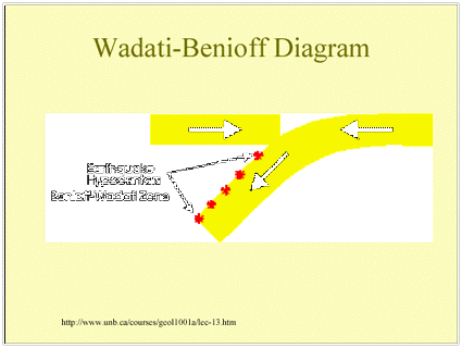
Fig. 9. Benioff zone schematic. From Goeke [2]
While these Benioff Zones are not really anywhere near as as well-defined as Figure 9 might suggest, they do exist. The question is, what do they mean?
In FE theory, the zones are regarded as representing ocean-floor spreading material being downthrust or 'subducted' under adjacent land (Figs. 7, 8). There is a test point here. If material was really being subducted along the zones, then the overriding land slab above the zone would be pushed against, and under compression.
This point is brought out in the London Geological Museum booklet Earthquakes [15], a standard FE treatment, which says "... shallow earthquakes in the overriding slab unexpectedly show tensional rather than compressional movements".
So the existence of Benioff Zones actually supports the EE view, which is that material is being pulled from under the land as the Earth expands, rather than the converse!
Earthquakes
An enormous body of data has been built up on the around 1 million detectable earthquakes which occur on Earth each year, but so far no wholly satisfactory mechanism for why they occur where they do has been put forward.
Of course earthquakes are only relative movements of adjacent pieces of the upper Earth, and are to be expected at plate boundaries in FE theory or along domain edges in EE theory, and the big majority of earthquakes do occur along such lines.
However, they also occur at places far away from plate boundaries, and FE theory has no explanation of this, or of why earthquake intensities can vary so much at different points along the same boundary, or from one boundary to another.
EE theory provides a possible explanation, looking at earthquake bands side-on instead of the usual top-down view. It seems that the most intense earthquakes occur where the relative local gradients are greatest. For example, the most intense earthquakes in North America occur in or off southern Alaska, including the 1964 Great Alaska Earthquake, recently re-classified to 9.2 on the Richter Scale.
This area also contains the highest mountain in North America, Mt Denali (Mt McKinley), at 6194 m, and this lies close to the Aleutian Trench, which goes down to 7679 m (although not directly opposite Mt Denali). In fact the average slope of Denali is greater than that of Mt Everest.
Similar situations occur along the west coast of South America and along the islands of Southeast Asia, all notorious for major earthquakes. It seems to me likely that earthquakes can be related directly to local gradients, with large gradients liable to large earthquakes as the higher land slumps into the lower levels (Fig. 10). It may be possible to set up computer models to predict where earthquakes will occur, with development of the physics of non-homogenous materials and taking into account continuous expansion under the crust.
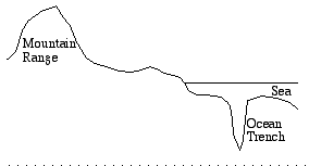
Fig. 10. Notional cross-section through a near-coastal mountain range and ocean trench.
We have seen that EE theory explains the formation of ocean trenches as the seabed is split by underlying expansion. Once formed, such a trench greatly magnifies the average local gradient and this can be expected to lead to active earthquake manifestation as material then slumps into the trench.
In summary, then, EE theory sees the movement of parts of the Crust and Upper Mantle as of two main types:
Type 1. Parasolid rearrangement. This is essentially the very slow rearrangement of bulk rock under the influence of pressure and gravity, similar to (but perhaps with a different underlying mechanism from) the flow of an extremely viscous liquid.
In EE theory, parasolid rearrangement is seen as the main mechanism acting within the Crust, upper Mantle and major continental and seafloor segments, including continental shields and massifs and the material underlying these. It is what keeps the Earth's shape essentially spherical over geological ages as its inner components undergo expansion and change underneath the land. The mechanism may generate heat, but not enough to lead to local 'geothermal' phenomena.
The mechanism is acting on materials which may be layered or otherwise non-homogenous, and which may differ in their chemical and physical structures.
Type 2. Local adjustment. These activities are on a smaller and more local scale, and include the matters currently treated by rock mechanics, physics of (perhaps anisotropic) solids, and the sciences of seismology and volcanology. Often they generate considerable heat, and are responsible for most 'geothermal' phenomena, including volcanos and production of igneous and metamorphic rocks.
There seems no basic reason why both these types of action could not be understood and researched further using computer modelling of the forces and materials involved. Obviously these models might be quite complex, given the varied natures and arrangements of the materials involved, but probably much less complex than those in current use to model weather patterns.
Some of the complications are in the varied nature and positioning of the rocks. For example, tilted rock strata may have a tendency to slip along a particular layer, and friction in this layer can then lead to partial or complete liquefaction in the layer, as occurs at the base of glaciers.
Rocks containing large obvious crystals, such as granites, are usually considered to have solidified slowly. However the increase in ice crystal size in flowing glaciers suggests that the same phenomenon in typical rocks may have similar origins.
Earthquake prediction.
In particular, computer modelling of Type 1 and Type 2 processes could yield, for the first time, workable predictions of where earthquakes were due to appear.
The question may be asked as to why surface features such as ocean trenches and mid-ocean ridges have appeared where they have, on the Earth's surface. Figure 11 is a schematic of an expanding interior capped by surface features of varying heights.
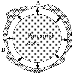
Fig. 11. Schematic of varying-height surface masses above an expanding parasolid interior.
If the question was asked as to where on this figure the surface would next be split open by expansion forces, the intuitive answer would probably be at A and B, where the land overlay is thinnest.
This answer gives some reason for why most of the deepest ocean trenches and mid-ocean ridges (remember these ridges lie within canyons some 1.6 km deep) appear in the Pacific Ocean, already the deepest of the oceans. Essentially, the lower the elevation of the surface section, the more liable it is to experience rifting caused by expansion.
Conversion of this hypothesis from intuition to scientific backing may have to await the computer modelling referred to, which might also explain why ocean trenches usually parallel land features, as implied by Fig. 8b.
Geothermal phenomena
Figure 12 shows a conventional (FE) schematic of the structure of a volcano. Lava is produced at the top, supposedly being squeezed out by rock pressure from a 'magma chamber' lower down. This is often shown as originating from a larger 'batholith' of molten rock even deeper down, and the batholith is represented as supplied from deeper molten rock from even lower down.
Of course such a representation is in flagrant contradiction to what we know of the laws of heat flow in solids and liquids. Even if, as may be, the Earth has hotter regions below, how could the heat from these be somehow concentrated and directed upwards in the manner suggested in Figure 12?
We have seen that the closest large-scale source of molten rock is in the Outer Core, some 2900 km down. How could such a source, of planetary scale, produce tiny and specific columns of molten rock travelling over such distances without their heat dissipating into the surroundings?
If batholiths really existed as major accumulations of deep molten rock, they should show up in seismological studies. So far they have not been detected.
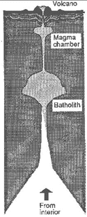
Fig.12. Conventional (FE) picture for origin of lava in a volcano (See also Fig. 8).
In the present EE theory, all active geothermal phenomena, including earthquakes, volcanos, igneous rock formation, and hot springs, are related to local friction due to relative movement, mostly at domain edges.
This explains why the lava from continental volcanos is of similar chemical composition to that of the surrounding continental rock, whereas ocean-floor volcanos have lava of similar composition to ocean-floor rock. It explains why igneous rock bodies identified as batholiths are not round, but are stretched out along the direction of the mountain range including them. And it explains chains of volcanos, as the Hawaiian series, as the effect of an irregular protrusion in one domain boundary moving against a more regular adjacent domain boundary.
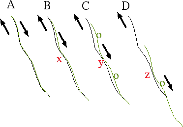
Fig.12b. Effects of displacement along a domain edge.
Origin of the Earth's heat
The average temperature on the Earth's surface is said to be some 20 deg C warmer than would be expected for an inert body in space at our planet's distance from the sun. At the same time, temperatures rise as much as 25 deg C per kilometre of depth in deep mines and boreholes. The question arises as to where this heat originates.
In older theories, when the great age of the Earth was not appreciated, this heat was believed to be original heat left over from the time of formation. But back in the 1800s, Lord Kelvin showed that such heat would all be dissipated in no more than 10 million years.
Later FE theory has ascribed this heat to decay of 'radioactive material', also left over from the time of origin of the Earth. However both sources can be ruled out as providers of the heat flow from beneath the surface currently observed, as both would be almost completely used up by now, while there is no indication from the past that the Earth's average temperatures were very markedly different in any past era. For example, ancient sedimentary rocks date back to at least 95% of the Earth's accepted age, so liquid water must have been present over all this time.
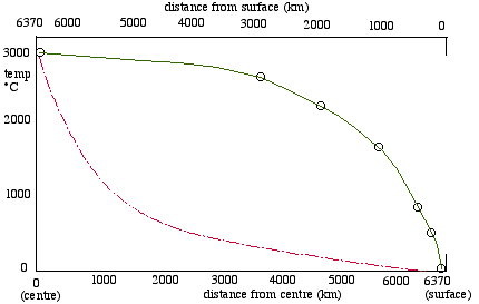
Fig. 13. Temperatures at depth within the Earth. Upper solid line: commonly quoted data; lower dashed line: typical temperature fall for linear conduction from a hot surface.
Figure 13 shows (upper solid line) a plot of believed temperatures within the Earth against distance from the centre. The values may not be especially accurate, but at the moment they are the best we have. What do they imply?
Close to the surface, the rate of temperature rise with depth is sharp, as much as 25 deg/km. Obviously this rate could not continue to the centre, else the temperature there would be 25 x 6370, some 160,000 deg C, instead of the 3000 deg commonly assumed.
Figure 13 also shows (lower dashed line) a typical curve for decrease in temperature due to linear conduction from a hot surface, the sort of curve that would be expected if the Earth's heat was being generated in some way at the centre. This curve is very different to the accepted-data one.
What the upper curve implies is that the majority of the heat showing up in flow from below the surface is generated in the upper 100-200 km, which ties in well with the Type 2 Local Adjustment activities suggested above. If, in fact, temperatures continue to rise, at a much slower rate, in the levels below this, this ties in well with the Type 1 Parasolid Adjustment activities.
Of course both heat sources are ultimately due, in EE theory, to expansion. The lesser Type 1 source is generated directly by the expansion process. Type 2 heating occurs by conversion of potential energy to heat, as higher land slumps into new rifts created by expansion, and by friction, as adjacent domains rub against each other.
Mountain building
A great deal of information has been accumulated on the Earth's past and present mountain ranges, with analyses of their ages and constituent rocks. An interesting point is that dates of apparent folding and upthrust of these ranges may have no relationship to the dates of formation of the bulk of the rocks they contain, except for igneous and metamorphic rocks which appear to have originated during the folding/upthrust process itself.
FE theory really has very little to say as to why mountain building should occur. Collisions between FE's 'tectonic plates' are a reasonable suggestion, but this does not explain the occurrence of high plateaus, as in Tibet, or of mountain ranges distant from the edges of 'plates'.
In EE theory, friction at adjacent domain edges is the analogue of tectonic plate collision, but the more intricate, multi-level, domain approach explains more of the less obvious cases. In addition, EE theory has two extra origins of elevated land to offer.
In FE theory, mountain ranges and high plateaus are treated as 'uplifted' from a lower base. In EE theory, everything is being 'uplifted' as the Earth expands, but much of the uplifted material will subsequently slump or be eroded into new, lower, rift or abyssal areas.
In this approach, a high plateau like that in Tibet was never uplifted, instead it was left high as a sort of 'mesa' as the land around it sank down. It may not be a coincidence that Tibet is a long way from the sea, and is surrounded by mountains or elevated land.
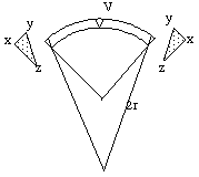
Another EE explanation for mountain building is based on the realization that this is virtually required as a consequence of the lesser curvature of land areas as the Earth expands beneath them.
Figures 14 and 15 are from an associated article on this site, FoilExperiment.htm, which examines this matter by graphical and mathematical analysis, and with an experimental analogy to Earth expansion using a set of pieces of aluminium foil wrapped around a conical section and then flattened.
 .
. 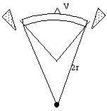
Fig. 14. Squeezing out a wedge of land material due to decreasing surface curvature on an expanding Earth.
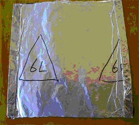
Fig. 15. Appearance of analogues of mountain ranges as aluminium foil sections undergo constrained flattening.
Conclusions
Ample evidence is given here that the Expanding Earth approach is far superior to the Fixed Earth approach in explaining observed data on the Earth, such that the Expanding Earth Theory should supplant the old Fixed Earth Theory as the currently accepted paradigm. One would imagine that no analysis based on scientific principles could reject this conclusion.
Nevertheless, scientific conservatism and entrenched opinions are such that it is likely to be some time before 'Fixed-Earthers' are regarded with the same sort of amusement currently accorded to those who believe that the Earth is flat.
Grateful thanks and acknowledgements are due to a host of workers who have provided much of the data and insights used in this article, especially to Prof Cliff Ollier of the University of Western Australia.